Factors That Influence Climate
There are many factors that influence climate, but there are some geologic and geographic factors that can play a big role.
- The sun: The sun is the primary source of energy for the Earth's climate system. The intensity of the sun's radiation can vary slightly over time, which can have an effect on the Earth's climate. Additionally, variance in seasons and latitude (season intensity in the Arctic, versus the United States, versus Ecuador, versus the Antarctic...) as we discussed before clearly contributes to unique climates. Solar radiation and its dispersion can greatly influence a climate.
- Earth's orbit: The shape of the Earth's orbit around the sun can affect the amount of solar energy that reaches the Earth's surface. The ellipse that our planet orbits on is not a circle, so climates can change depending on proximity.
- Greenhouse gases: Greenhouse gases (like CO2 or methane gas) heat our atmosphere since it absorbs energy. Contributions like mass deforestations and burning of fossil fuels maintain that humans have contributed the most to climate change and global warming. While this does irreparable damage to our planet and community, it also creates hotter, more abrasive, and more dangerous climates worldwide. It can also increase the likelihood of natural disasters, which may change the climate of a certain region if not avoided.
- Volcanoes: Large volcanic eruptions put out a lot of ashes and atmospheric gases, which cools the Earth's surface by blocking solar radiation. Be aware that this effect of the eruption will at most last several decades, and is not a permanent alteration to the climate. It also is not strong enough of a deterrent for our current situation regarding global warming.
- Ocean currents: The movement of the Earth's oceans can have a significant influence on climate because of the ocean's large heat capacity, meaning that it can store heat energy present on Earth. For example, a stream could carry warmer water into a coastal region which in turn warms the climate.
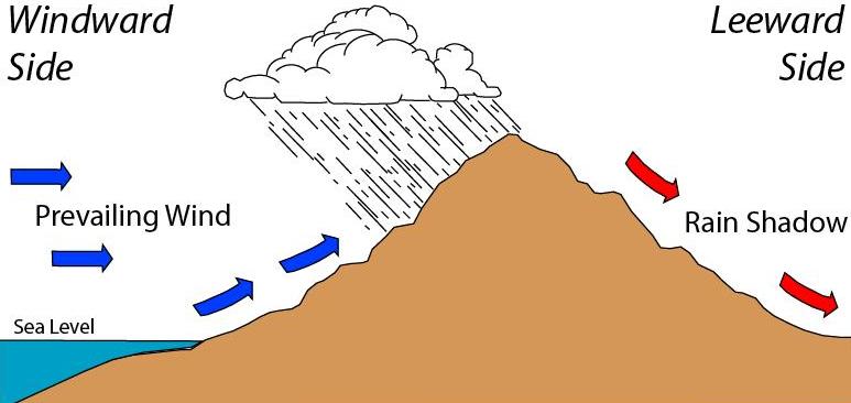
- Land masses: The shape and elevation of the Earth's land, like mountains can block the movement of air masses. This causes differences in temperature and precipitation on either side of the mountain range, and different conditions on the top of the mountain depending on its height (or altitude). The rain shadow effect results in one side of a mountain receiving more precipitation than the other side. On the windward side, warm, moist air rises up the mountain, cools, and falls as precipitation. However, on the leeward side, they don’t receive much precipitation because the air doesn’t have much moisture left.


🎥 Watch: AP Environmental Science Streams
Frequently Asked Questions
What's the difference between weather and climate?
Weather is short-term atmospheric conditions at a place and time—think daily temperature, rain, wind, humidity, storms. Climate is the long-term pattern of those conditions, usually summarized as averages and extremes over ~30 years (the standard WMO baseline), and describes what you expect (hot/dry, mild/wet) rather than what you get today. For APES Topic 4.8, remember both are driven by the sun’s energy but modified by geography and geology (EK ENG-2.B.1): mountains (orographic lift, rain shadows), ocean temperature and currents (El Niño), continentality, jet stream, and albedo all shape regional climate. On the exam, questions may ask you to distinguish short-term weather events from long-term climate trends or explain how features like mountain ranges create rain shadow deserts (EK ENG-2.B.2). For review, see the Topic 4 study guide (https://library.fiveable.me/ap-environmental-science/unit-4/earths-geography-climate/study-guide/NA6ZNBygB1NgmyYP3xjV), the Unit 4 overview (https://library.fiveable.me/ap-environmental-science/unit-4), and practice problems (https://library.fiveable.me/practice/ap-environmental-science).
How do mountains affect rainfall patterns?
Mountains change rainfall by forcing air to rise—called orographic lift. Moist air hits the windward side, rises, cools (about 6.5°C per km), and water vapor condenses, causing orographic precipitation. That makes the windward slopes wetter and often forested. After the air loses moisture and descends the leeward side, it warms and dries, producing a rain shadow—a much drier region that can become a rain-shadow desert. Downslope foehn/Chinook winds are warm, dry winds that reinforce drying on the leeward side. These ideas (rain shadow, windward/leeward, orographic precipitation, foehn winds) are in the CED learning objective ENG-2.B and commonly tested in Unit 4 questions. For a quick review, check the Topic 4.8 study guide on Fiveable (https://library.fiveable.me/ap-environmental-science/unit-4/earths-geography-climate/study-guide/NA6ZNBygB1NgmyYP3xjV) and grab practice problems at (https://library.fiveable.me/practice/ap-environmental-science).
Why is one side of a mountain wet and the other side dry?
When moist air hits a mountain range it’s forced upward—that’s orographic lift. Rising air cools, water vapor condenses, and the windward side gets clouds and precipitation (orographic precipitation). After the air drops most of its moisture and descends on the other side, it warms and dries, creating a rain shadow on the leeward side. So one side is wet (windward) and the other dry (leeward/rain shadow). You might also hear foehn or Chinook winds for the warm, dry downslope air. This is exactly what EK ENG-2.B.2 describes and is tested under ENG-2.B on the AP: know terms like rain shadow, orographic lift, windward/leeward, and orographic precipitation. For more review, see the Topic 4.8 study guide (https://library.fiveable.me/ap-environmental-science/unit-4/earths-geography-climate/study-guide/NA6ZNBygB1NgmyYP3xjV), the Unit 4 overview (https://library.fiveable.me/ap-environmental-science/unit-4), and practice questions (https://library.fiveable.me/practice/ap-environmental-science).
What is a rain shadow and how does it form?
A rain shadow is a dry region on the leeward (downwind) side of a mountain where precipitation is greatly reduced. Moist air approaches the mountain on the windward side and is forced upward (orographic lift). As the air rises it cools, water vapor condenses, and orographic precipitation falls on the windward slopes. After losing moisture, the now-drier air descends the leeward slope, warms (often producing warm, dry foehn/Chinook winds), and holds more moisture, so little precipitation occurs—that area is the rain shadow. Big-picture: mountains strongly shape local climate (ENG-2.B in the CED), creating wetter windward zones and potential rain-shadow deserts on the leeward side. For AP review, see the Topic 4.8 study guide (https://library.fiveable.me/ap-environmental-science/unit-4/earths-geography-climate/study-guide/NA6ZNBygB1NgmyYP3xjV) and practice questions (https://library.fiveable.me/practice/ap-environmental-science).
I'm confused about how ocean temperature affects climate - can someone explain?
Oceans store and move huge amounts of heat, so sea-surface temperature strongly shapes climate. Warm ocean water releases heat and moisture into the air, warming nearby land and increasing precipitation (think coastal tropics). Cold surface water cools air and often leads to drier, cooler coasts. Ocean temperature also controls currents and upwelling: cold, nutrient-rich upwelling supports productive fisheries, but during El Niño warm surface water suppresses upwelling off South America, reducing fish and changing regional rain patterns (EK ENG-2.B.1; El Niño–Southern Oscillation). Large-scale ocean warming can shift the jet stream, changing storm tracks and creating longer droughts or floods. Finally, warmer oceans absorb less CO2 and changing CO2 uptake drives ocean acidification (lower pH), which affects marine life (coral bleaching, altered metabolism). For AP review, see the Topic 4.8 study guide (https://library.fiveable.me/ap-environmental-science/unit-4/earths-geography-climate/study-guide/NA6ZNBygB1NgmyYP3xjV) and hit the practice problems (https://library.fiveable.me/practice/ap-environmental-science).
How does the sun's energy interact with geographic features to create different climates?
The Sun’s energy sets the baseline—it heats the atmosphere and oceans—but geography shapes how that energy makes climate. Latitude controls incoming solar angle (higher lat = less energy). Large water bodies moderate temperature (continentality: inland places have bigger temp swings; coasts are milder). Ocean currents move heat: warm currents warm nearby coasts, cold currents cool them and drive coastal upwelling (nutrient-rich waters). Mountains force air to rise (orographic lift): air cools and dumps moisture on the windward side (orographic precipitation), leaving a dry leeward rain shadow and sometimes warm foehn/Chinook winds. Albedo (ice, snow, deserts) changes how much solar energy is reflected. Large-scale patterns—jet stream shifts, El Niño—redistribute heat and precipitation. These are CED concepts you should know for ENG-2.B (see the Topic 4.8 study guide for a quick review: https://library.fiveable.me/ap-environmental-science/unit-4/earths-geography-climate/study-guide/NA6ZNBygB1NgmyYP3xjV). For practice, try problems at Fiveable’s practice page (https://library.fiveable.me/practice/ap-environmental-science).
Why are some places really dry even though they're near water?
Places near water can still be dry for a few geographic reasons. The big one is a rain shadow: moist air hits mountains, rises (orographic lift), cools and drops rain on the windward side, so the leeward side gets dry air—that creates deserts in the mountain’s shadow (think Great Basin or parts of Patagonia). Cold ocean currents and coastal upwelling can also keep nearby coasts dry because cooler surface water stabilizes the air and reduces evaporation, so places like the Atacama stay arid. Continentality matters too: far from oceans, inland regions get less moisture. These are exactly the CED concepts in Topic 4.8 (ENG-2.B): rain shadow, orographic precipitation, windward/leeward, ocean currents, and continentality. For a quick review, check Fiveable’s Topic 4.8 study guide (https://library.fiveable.me/ap-environmental-science/unit-4/earths-geography-climate/study-guide/NA6ZNBygB1NgmyYP3xjV) and Unit 4 overview (https://library.fiveable.me/ap-environmental-science/unit-4). Practice questions are at (https://library.fiveable.me/practice/ap-environmental-science).
What happens when air hits a mountain range?
When moist air blows toward a mountain range it’s forced upward—that’s called orographic lift. As the air rises it cools, water vapor condenses, and you get orographic precipitation on the windward side (rain or snow). By the time the air crosses the peak it’s lost much moisture, so descending air on the leeward side is drier and warmer; that creates a rain shadow region and often rain-shadow deserts. Fast downhill winds that have been warmed by compression are called foehn or Chinook winds. This whole process (windward = wet, leeward = dry) is exactly the kind of geographic control on climate the AP CED expects you to describe (ENG-2.B; EK ENG-2.B.1–2). For a quick review, see the Topic 4.8 study guide (https://library.fiveable.me/ap-environmental-science/unit-4/earths-geography-climate/study-guide/NA6ZNBygB1NgmyYP3xjV) and try practice problems (https://library.fiveable.me/practice/ap-environmental-science) to prep for exam questions.
How do geologic factors influence weather patterns?
Geologic features shape weather by changing how air moves, heats, and gets moisture. Mountains force air up (orographic lift) on the windward side, cooling it and causing orographic precipitation; the leeward side gets dry air and a rain shadow (rain shadow deserts, foehn/Chinook winds). Large landmasses show continentality—bigger temperature swings inland vs. milder coastal climates. Ocean-adjacent geology (continental shelves, coastal upwelling like off the Andes) controls sea surface temperatures and nutrient upwelling, which affect local winds and precipitation; ENSO (El Niño) shifts warm water eastward, reducing upwelling and altering global weather. High elevations and ice/snow change albedo, altering local heating and jet stream patterns, which steer storms. For AP prep, focus on these CED terms (rain shadow, windward/leeward, orographic precipitation, continentality, upwelling, El Niño, albedo)—see the Topic 4.8 study guide on Fiveable (https://library.fiveable.me/ap-environmental-science/unit-4/earths-geography-climate/study-guide/NA6ZNBygB1NgmyYP3xjV) and practice Unit 4 questions (https://library.fiveable.me/practice/ap-environmental-science).
I don't understand how elevation affects precipitation - help?
Elevation strongly controls where precipitation falls because air cools as it rises. When moist air encounters a mountain it’s forced upward (orographic lift). Rising air expands and cools, water vapor condenses, and you get orographic precipitation on the windward side—that side is wetter and supports lush vegetation. After the air passes the peak it descends the leeward side, warms, and dries, creating a rain shadow (often a rain shadow desert). Foehn or Chinook winds are warm, dry downslope winds that amplify drying on the leeward side. So: windward = wet, leeward = dry. This concept (EK ENG-2.B.1 and EK ENG-2.B.2) shows how geography shapes climate and is testable on the AP exam—you might see maps or ask to explain rain shadows. For a quick review, see the Topic 4.8 study guide (https://library.fiveable.me/ap-environmental-science/unit-4/earths-geography-climate/study-guide/NA6ZNBygB1NgmyYP3xjV) and practice questions (https://library.fiveable.me/practice/ap-environmental-science).
What's the relationship between mountain barriers and desert formation?
Mountains cause deserts through orographic lift and rain shadows (CED EK ENG-2.B.2). Moist air hits the windward side, is forced up (orographic lift), cools, and loses moisture as orographic precipitation. By the time air crosses the crest to the leeward side, it’s much drier and warms (foehn/Chinook effect), so little precipitation falls—that dry area is a rain shadow desert. Examples: the Atacama and parts of eastern Washington. This concept is tested on APES as part of Topic 4.8 (ENG-2.B)—know windward vs. leeward, orographic precipitation, and “rain shadow” for multiple-choice and free-response reasoning. For a quick review, see the Topic 4.8 study guide (https://library.fiveable.me/ap-environmental-science/unit-4/earths-geography-climate/study-guide/NA6ZNBygB1NgmyYP3xjV) and practice questions (https://library.fiveable.me/practice/ap-environmental-science).
Why do coastal areas have different climates than inland areas?
Coastal climates differ from inland ones mainly because oceans moderate temperature and supply moisture. Water has high heat capacity, so coastal areas warm and cool more slowly (maritime effect), giving smaller daily and seasonal temperature ranges than continental interiors (continentality). Onshore winds bring humid air, so coasts often have higher precipitation—especially where air rises over mountains (orographic lift) causing windward rainfall and a leeward rain shadow. Ocean currents and coastal upwelling also change local temps and nutrient supply (cold upwelling cools nearby coasts and fuels productivity). Large-scale patterns (ENSO/El Niño, jet stream shifts) alter coastal storms and upwelling strength, so some years are wetter or drier. Albedo differences (sea vs. land/ice) can amplify warming locally, especially in polar coasts. These are the exact CED concepts you’ll need for ENG-2.B on the exam—review Topic 4.8 on Fiveable for a quick study guide (https://library.fiveable.me/ap-environmental-science/unit-4/earths-geography-climate/study-guide/NA6ZNBygB1NgmyYP3xjV) and hit practice questions (https://library.fiveable.me/practice/ap-environmental-science).
How does topography create microclimates?
Topography creates microclimates by changing how air moves, heats, and holds moisture over short distances. Mountains force air up (orographic lift), cooling it and causing orographic precipitation on the windward side; the leeward side gets dry rain-shadow conditions (think desert on one side, lush forest on the other). Elevation lowers temperature about 6°C per 1,000 m, so peaks are colder than nearby lowlands. Slope aspect matters: south-facing slopes in the Northern Hemisphere get more sun (warmer, drier) than north-facing slopes. Valleys trap cold air at night (cold-air pooling), creating frost pockets. Föhn/Chinook winds heat and dry air descending mountains, producing sudden warm spells. These are exactly the kinds of geography–climate links asked in ENG-2.B on the APES CED (rain shadow, orographic precipitation, windward/leeward). For more review, see the Topic 4.8 study guide (https://library.fiveable.me/ap-environmental-science/unit-4/earths-geography-climate/study-guide/NA6ZNBygB1NgmyYP3xjV) and practice questions (https://library.fiveable.me/practice/ap-environmental-science).
Can you explain step by step what happens to air masses when they encounter mountains?
When an air mass meets a mountain range, here’s what happens step by step: 1. Windward flow: Prevailing winds push the air up the mountain (windward side). 2. Orographic lift: Rising air expands and cools adiabatically. Use dry adiabatic lapse ≈10°C/km until saturation, then moist lapse ≈6°C/km. 3. Condensation & orographic precipitation: Cooling reaches the dew point → clouds form and precipitation falls on the windward side, releasing latent heat. 4. Moist stabilization: Because of latent heat, uplift can be sustained, enhancing precipitation (think Andes coastal upwelling + mountains). 5. Leeward descent: Air crosses the crest, descends the leeward side, compresses and warms at the dry lapse rate. 6. Rain shadow & foehn/Chinook winds: Warming, drying air produces a dry region (rain shadow desert) and sometimes warm, gusty foehn/Chinook winds. This process is an AP staple (EK ENG-2.B.1–2)—review the Topic 4.8 study guide (https://library.fiveable.me/ap-environmental-science/unit-4/earths-geography-climate/study-guide/NA6ZNBygB1NgmyYP3xjV) and practice problems (https://library.fiveable.me/practice/ap-environmental-science).
What are some real world examples of rain shadows and why do they occur there?
Common real-world rain shadows and why they form: - Andes → Atacama Desert (Chile): Moist Pacific air hits the Andes, rises and drops most moisture on the windward side (orographic precipitation). The air descending the leeward (eastern) side is dry, creating one of the driest places on Earth. - Cascades (Pacific NW) → Eastern Washington/Columbia Basin: Pacific westerlies bring moisture, rain on the windward slopes; the leeward side is much drier (semi-arid). - Sierra Nevada → Eastern Sierra/Great Basin (including Death Valley region): Sierra uplift causes heavy western precipitation; descending air eastward produces desert conditions. - Himalaya → Tibetan Plateau: Moist monsoon air loses moisture on the southern slopes; the plateau stays dry (rain shadow). Why it happens (CED terms): moist air forced up mountain slopes (orographic lift) cools and condenses (windward side) producing orographic precipitation. After crossing the crest, air descends, warms (foehn/Chinook effect), and its relative humidity drops, producing a dry leeward rain shadow—sometimes a rain shadow desert. For AP review, see the Topic 4.8 study guide (https://library.fiveable.me/ap-environmental-science/unit-4/earths-geography-climate/study-guide/NA6ZNBygB1NgmyYP3xjV) and more Unit 4 resources (https://library.fiveable.me/ap-environmental-science/unit-4).