AP HUG Free-Response Questions (FRQ) - Past Prompts
11 min read•april 6, 2021
Dalia Savy
Harrison Burnside
Dalia Savy
Harrison Burnside
Overview
We’ve compiled a list of a bunch of the AP Human Geography past prompts!
By practicing with previously released free-response questions (FRQs), you’ll build critical thinking and analytical skills that will prepare you for the exam. These past prompts have been designed to help you connect concepts and ideas to each other while applying your knowledge to real-life scenarios. Make sure you know your vocabulary and practice below with past exam questions.
All credit to College Board.
2019 FRQs
👉AP Human Geography 2019 FRQs Set 1
👉AP Human Geography 2019 FRQs Set 2
Set 1, Question 1
Unit 6: Food Deserts
In the early twenty-first century, food security is an increasingly important issue in developed countries. Some neighborhoods in United States cities have been characterized as food deserts. Food deserts are areas with little or no access to healthy and affordable food or limited or no access to fresh fruits and vegetables.
Describe what kinds of information geographers use to map food deserts.
Identify and explain TWO reasons that food deserts exist in urban areas within developed countries.
Identify and explain ONE impact of living in a food desert.
Set 1, Question 2
Unit 2: Infant Mortality Trends
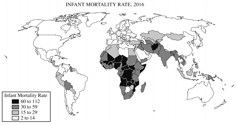
Infant mortality varies widely around the world and is affected by complex real-world characteristics. The infant mortality rate is a key demographic indicator that can be used to assess social, economic, and other conditions at multiple geographic scales.
Identify the predominant ranges of the infant mortality rate found in South Asia and in western Europe.
Describe TWO economic reasons for the level of infant mortality rates in western Europe.
Identify and explain a specific way in which each of the following TWO United Nations Sustainable Development Goals are intended to affect infant mortality rates in a rural community in South Asia.
Quality education
Clean water and sanitation
Set 1, Question 3
Unit 4: Devolution
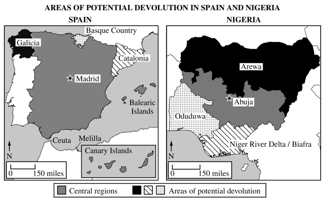
The number of states in the world has grown to approximately 200. The creation of new countries has been possible as a result of devolutionary forces. Countries such as Spain and Nigeria face devolutionary pressures.
Define devolution.
Describe how each of the following forces contributes to devolutionary pressures within a country.
Cultural diversity
Regional economic differences
Physical geography and territorial size
Identify and explain ONE political impact resulting from devolutionary pressures related to cultural differences in either Spain or Nigeria.
Set 2, Question 1
Unit 7: Deindustrialization
Many developed countries have deindustrialized and are transitioning to a postindustrial economy.
Identify and describe the economic sector that becomes dominant when a country deindustrializes and restructures from an industrial to a postindustrial economy.
Describe TWO ways countries transitioning to a postindustrial economy utilize the international division of labor.
Describe ONE way in which the roles of women in the paid labor force of developed countries change as a result of the transition to a post-industrial economy.
Describe TWO ways in which brownfields can be redeveloped in postindustrial cities.
Set 2, Question 2
Unit 6: Galactic City Model
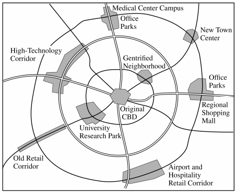
The model shown is known as the galactic city model, sometimes described as the contemporary urban model of the North American metropolitan area. Among the features within this model are edge cities. Edge cities are large centers of development on the urban periphery.
Describe TWO factors that led to the development of the galactic city as an urban landscape in North America.
Describe TWO ways that the spatial organization of commercial land use is different between the original central business district (CBD) and an edge city.
Describe ONE negative impact of edge city development on the environment.
Explain TWO ways sustainable design initiatives or smart growth policies could address negative impacts of edge city development on the environment.
Set 2, Question 3
Unit 4: International Boundaries in Europe, 1980-2013
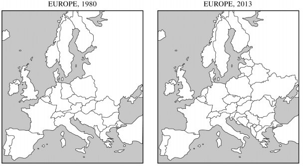
As shown in the maps, international boundaries in Europe changed considerably from 1980 to 2013. Nationalism and supranationalism were two geographical processes that changed the number and function of those boundaries.
Identify ONE geopolitical event that initiated change in the number of international boundaries in Europe between 1980 and 2013.
Explain how nationalism can eliminate an international boundary. Describe an example from the maps shown.
Explain how nationalism can create new international boundaries. Describe an example from the maps shown.
Describe TWO ways supranationalism has affected the functions of international boundaries in Europe.
2018 FRQs
Question 1
Unit 7: Gender Equality & Empowerment
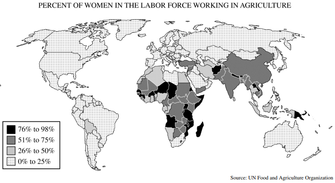
Women compose between one-third and one-half of all agricultural laborers in developing countries, and yet empowerment and gender equality have been difficult to achieve.
Identify a country where more than 75 percent of women in the labor force are active in agriculture.
For each of the following THREE categories, describe ONE obstacle that may prevent women working in agriculture from achieving greater gender equality and empowerment.
Economic
Cultural
Political
Identify and explain ONE impact of empowering women within the rural agricultural regions of developing countries.
Question 2
Unit 6: Gentrification
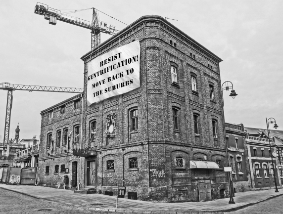
The older neighborhood shown in the picture is undergoing changes in its demographic profile as the existing built landscape is renovated.
Explain TWO ways that gentrification may positively impact neighborhoods.
Explain TWO ways that gentrification may negatively impact neighborhoods.
Identify and explain ONE way that city governments may reduce the negative impacts of gentrification.
Question 3
Unit 3: Cultural Diffusion
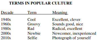
Identify TWO specific means by which new expressions in popular culture are diffused globally.
Popular culture often spreads through a combination of different types of diffusion. Describe how terms, such as those shown in the table, diffuse spatially through each of the following processes.
Relocation Diffusion
Contagious Diffusion
Hierarchical Diffusion
When new words diffuse, they confront barriers. Identify and explain TWO barriers to diffusion that are often encountered even as new terms become more popular.
2017 FRQs
Question 1
Unit 6: Mixed-Use Development and New Urbanism
In the last half of the twentieth century some United States cities experienced decline due to deindustrialization and loss of population due to suburbanization. To counteract the inner-city decline, urban planners have embraced New Urbanism and mixed-use development to attract residents back to the city.
Identify TWO goals of the New Urbanism movement.
Explain the differences between mixed-use development and traditional zoning practices.
Explain TWO benefits of mixed-use development in promoting urban growth.
Explain TWO criticisms of New Urbanism.
Question 2
Unit 2: Population Growth, Rate of Natural Increase, and Anti-Natal Policies
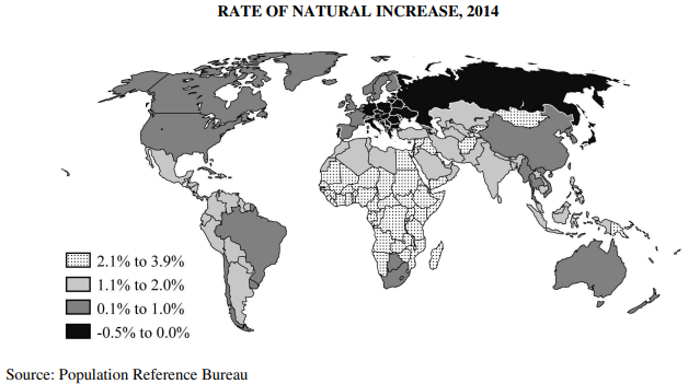
The map shows rates of natural increase in the human population.
Identify the world region on the map with the highest rates of natural increase.
Using the region identified in part A, explain THREE factors that contribute to high population growth rates.
Describe ONE economic incentive that a country with a high population growth rate could use to decrease population growth, and identify ONE potential impact of this strategy.
Describe ONE social program or policy that a country with a high population growth rate could use to decrease population growth, and identify ONE potential impact of this strategy.
Question 3
Unit 4: Federal and Unitary Governments
Political geographers classify most countries as either unitary states or federal states.
Define unitary state and identify the country shown that fits the definition of a unitary state.
Explain ONE positive and ONE negative impact of a unitary system.
Identify and explain ONE reason why some countries are governed as federal states.
2016 FRQs
Question 1
Unit 7: Development
Development results in a number of economic and social changes within a country.
Identify primary, secondary, and tertiary economic activities.
Explain TWO different reasons for each of the following changes that typically occur as a country develops over time.
Declines in primary sector employment
Decreases in infant mortality rates
Improvements in women's social status
Question 2
Unit 4: Politics of Language
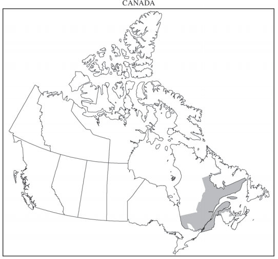
Many countries around the world, including Canada, have more than one official language.
Identify the primary language spoken by most inhabitants in the shaded area on the map.
Explain how bilingualism can have a positive impact on a country.
Explain how bilingualism can have a negative impact on a country.
Discuss TWO reasons, other than language, why Canada does not fit the nation-state concept.
Question 3
Unit 5: Subsistence and Commercial Agriculture and their Impacts
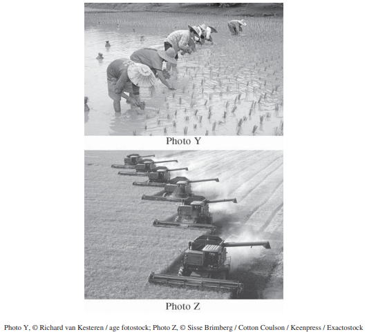
The pictures show two types of agriculture in the world.
Identify the grain crop shown in the photo.
Discuss TWO economic differences between subsistence agriculture and commercial agriculture.
Identify ONE environmental impact resulting from the type of agriculture shown in photo Y.
Identify ONE environmental impact resulting from the type of agriculture shown in photo Z.
2015 FRQs
Question 1
Unit 4: Gerrymandering and Reapportionment
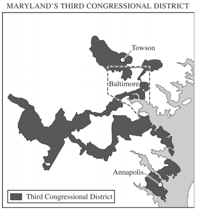
In the redistricting that occurred in 2012, voters in Maryland approved a redrawn Third Congressional District, as shown in the map above. A geospatial analysis firm named it the least compact district in the nation.
Identify the political phenomenon represented on the map.
Explain the relationship between redistricting and the census.
Identify and discuss TWO political consequences that could result from redistricting.
Question 2
Unit 3: English as the World's Lingua Franca
English is the most widely used language in the world, thus becoming the world’s lingua franca.
Define the term “lingua franca.”
Identify and describe ONE historical factor that contributed to the worldwide use of English.
Identify and explain TWO examples that show how globalization is contributing to English becoming the world’s lingua franca.
Question 3
Unit 2: Refugees and their Impacts on their Countries of Origin and Receiving Countries
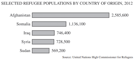
In recent years, the number of refugees has been increasing. However, most refugees come from just a few countries.
Define the term “refugee.”
Discuss ONE political, ONE social, and ONE environmental reason why refugees flee their country of origin.
Using the chart shown, select a country of origin; then identify and explain ONE reason why refugees have left the country.
Explain TWO economic impacts that refugees can have on a receiving country.
2014 FRQs
Question 1
Unit 4: Consequences of Superimposed Borders in Africa
Rostow’s five-stage model of economic growth and the core-periphery concept of Wallerstein’s three-part world system theory are two of the more common economic development models.
Identify and compare three differences between the stages of economic growth and the core-periphery model.
Use one of the two models to explain the level of economic development in either Mexico or Brazil.
Give two examples of how the core-periphery concept can be applied below the national scale.
Question 2
Unit 7: Compare Rostow & Wallerstein Models of Development
The international borders of African countries are a legacy of colonialism.
Describe the concept of a superimposed boundary.
Describe three political or cultural consequences of superimposed boundaries in Africa.
Identify and explain one challenge landlocked African countries face in developing viable economies.
Question 3
Unit 5: Effects of Coffee Production of Producer & Consumer Countries
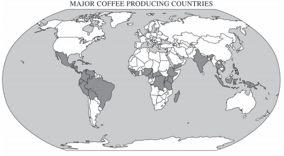
Agricultural systems, such as the production of coffee, are part of a global network.
Describe a common characteristic shared by the coffee-producing countries shown on the map.
Explain two impacts of coffee farming on producing countries.
Identify and explain one way increased coffee consumption outside of coffee growing areas affects its production.
Explain one change in the urban landscape in the developed world associated with coffee consumption.
2013 FRQs
Question 1
Unit 7: Agglomeration Industries
The high-tech centers of Silicon Valley in California and the Research Triangle in North Carolina developed in the past 40 years.
Discuss the following three factors that contributed to the rise of such industrial regions.
Investment capital
Labor
Government
Define the concept of agglomeration and explain its role in the continuing expansion of such regions.
Question 2
Unit 2: Reasons for and Consequences of Aging Populations in Developing Countries
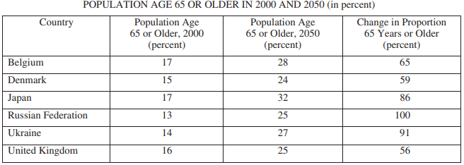
The average age of the population in selected developed countries listed in the table above has been increasing.
Identify and explain two reasons that the average population age is increasing in developed countries.
Identify and explain one social consequence and one economic consequence that countries face as their populations age.
Question 3
Unit 6: Influence of Transportation Model on Urban Growth Patterns
Over the past 150 years, railroad and highway systems influenced patterns of urban growth in the United States.
Identify and explain one way that railroads affected the size and one way that railroads affected the form of cities in the United States between 1870 and 1920.
Identify and explain two ways that the Interstate Highway System affected cities in the United States between 1950 and today.
2012 FRQs
Question 1
Unit 4: Border Walls and Barriers
Walls and other barriers built by countries to establish their borders are some of the oldest and most controversial elements in the cultural landscape.
Identify three examples of walls or other barriers built by countries in the twentieth and twenty-first centuries.
Explain the purpose of one of the examples you identified in part a.
For each of the categories listed below, discuss a consequence faced by countries as a result of walls or other barriers established along their borders.
social or political
economic
environmental
Question 2
Unit 5: Subsistence Farming and Shifting Cultivation
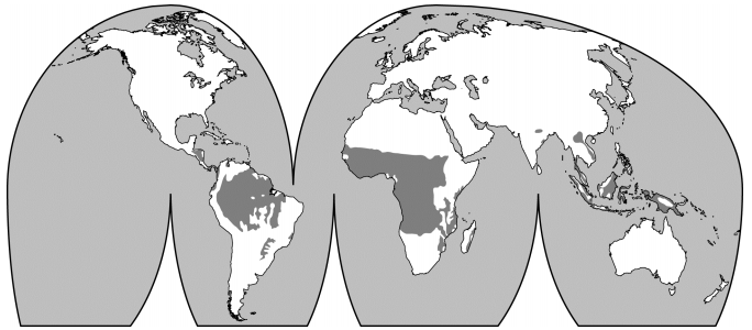
The map above shows areas of shifting cultivation, a form of subsistence agriculture.
Define subsistence agriculture.
Describe the practice of shifting cultivation.
Explain one reason why shifting cultivation was sustainable in the past.
Explain two reasons why shifting cultivation is expected to diminish during the twenty-first century
Question 3
Unit 2: Muslim Populations Growth in Europe
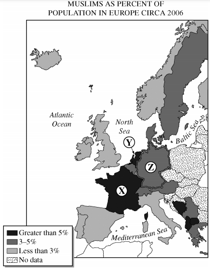
European countries have experienced an increase in Muslim population in recent decades. The map above shows the distribution and proportion of Muslims by country.
Identify Countries X, Y, and Z on the map above.
Explain two reasons for the increase in Muslim immigration to one of these countries since 1950.
For the country you selected in part b, discuss the impacts of the Muslim population increase on the country’s
urban spatial organization
population structure
social relations
Older FRQ Links
AP HUG Free-Response Questions (FRQ) - Past Prompts
11 min read•april 6, 2021
Dalia Savy
Harrison Burnside
Dalia Savy
Harrison Burnside
Overview
We’ve compiled a list of a bunch of the AP Human Geography past prompts!
By practicing with previously released free-response questions (FRQs), you’ll build critical thinking and analytical skills that will prepare you for the exam. These past prompts have been designed to help you connect concepts and ideas to each other while applying your knowledge to real-life scenarios. Make sure you know your vocabulary and practice below with past exam questions.
All credit to College Board.
2019 FRQs
👉AP Human Geography 2019 FRQs Set 1
👉AP Human Geography 2019 FRQs Set 2
Set 1, Question 1
Unit 6: Food Deserts
In the early twenty-first century, food security is an increasingly important issue in developed countries. Some neighborhoods in United States cities have been characterized as food deserts. Food deserts are areas with little or no access to healthy and affordable food or limited or no access to fresh fruits and vegetables.
Describe what kinds of information geographers use to map food deserts.
Identify and explain TWO reasons that food deserts exist in urban areas within developed countries.
Identify and explain ONE impact of living in a food desert.
Set 1, Question 2
Unit 2: Infant Mortality Trends
Infant mortality varies widely around the world and is affected by complex real-world characteristics. The infant mortality rate is a key demographic indicator that can be used to assess social, economic, and other conditions at multiple geographic scales.
Identify the predominant ranges of the infant mortality rate found in South Asia and in western Europe.
Describe TWO economic reasons for the level of infant mortality rates in western Europe.
Identify and explain a specific way in which each of the following TWO United Nations Sustainable Development Goals are intended to affect infant mortality rates in a rural community in South Asia.
Quality education
Clean water and sanitation
Set 1, Question 3
Unit 4: Devolution
The number of states in the world has grown to approximately 200. The creation of new countries has been possible as a result of devolutionary forces. Countries such as Spain and Nigeria face devolutionary pressures.
Define devolution.
Describe how each of the following forces contributes to devolutionary pressures within a country.
Cultural diversity
Regional economic differences
Physical geography and territorial size
Identify and explain ONE political impact resulting from devolutionary pressures related to cultural differences in either Spain or Nigeria.
Set 2, Question 1
Unit 7: Deindustrialization
Many developed countries have deindustrialized and are transitioning to a postindustrial economy.
Identify and describe the economic sector that becomes dominant when a country deindustrializes and restructures from an industrial to a postindustrial economy.
Describe TWO ways countries transitioning to a postindustrial economy utilize the international division of labor.
Describe ONE way in which the roles of women in the paid labor force of developed countries change as a result of the transition to a post-industrial economy.
Describe TWO ways in which brownfields can be redeveloped in postindustrial cities.
Set 2, Question 2
Unit 6: Galactic City Model
The model shown is known as the galactic city model, sometimes described as the contemporary urban model of the North American metropolitan area. Among the features within this model are edge cities. Edge cities are large centers of development on the urban periphery.
Describe TWO factors that led to the development of the galactic city as an urban landscape in North America.
Describe TWO ways that the spatial organization of commercial land use is different between the original central business district (CBD) and an edge city.
Describe ONE negative impact of edge city development on the environment.
Explain TWO ways sustainable design initiatives or smart growth policies could address negative impacts of edge city development on the environment.
Set 2, Question 3
Unit 4: International Boundaries in Europe, 1980-2013
As shown in the maps, international boundaries in Europe changed considerably from 1980 to 2013. Nationalism and supranationalism were two geographical processes that changed the number and function of those boundaries.
Identify ONE geopolitical event that initiated change in the number of international boundaries in Europe between 1980 and 2013.
Explain how nationalism can eliminate an international boundary. Describe an example from the maps shown.
Explain how nationalism can create new international boundaries. Describe an example from the maps shown.
Describe TWO ways supranationalism has affected the functions of international boundaries in Europe.
2018 FRQs
Question 1
Unit 7: Gender Equality & Empowerment
Women compose between one-third and one-half of all agricultural laborers in developing countries, and yet empowerment and gender equality have been difficult to achieve.
Identify a country where more than 75 percent of women in the labor force are active in agriculture.
For each of the following THREE categories, describe ONE obstacle that may prevent women working in agriculture from achieving greater gender equality and empowerment.
Economic
Cultural
Political
Identify and explain ONE impact of empowering women within the rural agricultural regions of developing countries.
Question 2
Unit 6: Gentrification
The older neighborhood shown in the picture is undergoing changes in its demographic profile as the existing built landscape is renovated.
Explain TWO ways that gentrification may positively impact neighborhoods.
Explain TWO ways that gentrification may negatively impact neighborhoods.
Identify and explain ONE way that city governments may reduce the negative impacts of gentrification.
Question 3
Unit 3: Cultural Diffusion
Identify TWO specific means by which new expressions in popular culture are diffused globally.
Popular culture often spreads through a combination of different types of diffusion. Describe how terms, such as those shown in the table, diffuse spatially through each of the following processes.
Relocation Diffusion
Contagious Diffusion
Hierarchical Diffusion
When new words diffuse, they confront barriers. Identify and explain TWO barriers to diffusion that are often encountered even as new terms become more popular.
2017 FRQs
Question 1
Unit 6: Mixed-Use Development and New Urbanism
In the last half of the twentieth century some United States cities experienced decline due to deindustrialization and loss of population due to suburbanization. To counteract the inner-city decline, urban planners have embraced New Urbanism and mixed-use development to attract residents back to the city.
Identify TWO goals of the New Urbanism movement.
Explain the differences between mixed-use development and traditional zoning practices.
Explain TWO benefits of mixed-use development in promoting urban growth.
Explain TWO criticisms of New Urbanism.
Question 2
Unit 2: Population Growth, Rate of Natural Increase, and Anti-Natal Policies
The map shows rates of natural increase in the human population.
Identify the world region on the map with the highest rates of natural increase.
Using the region identified in part A, explain THREE factors that contribute to high population growth rates.
Describe ONE economic incentive that a country with a high population growth rate could use to decrease population growth, and identify ONE potential impact of this strategy.
Describe ONE social program or policy that a country with a high population growth rate could use to decrease population growth, and identify ONE potential impact of this strategy.
Question 3
Unit 4: Federal and Unitary Governments
Political geographers classify most countries as either unitary states or federal states.
Define unitary state and identify the country shown that fits the definition of a unitary state.
Explain ONE positive and ONE negative impact of a unitary system.
Identify and explain ONE reason why some countries are governed as federal states.
2016 FRQs
Question 1
Unit 7: Development
Development results in a number of economic and social changes within a country.
Identify primary, secondary, and tertiary economic activities.
Explain TWO different reasons for each of the following changes that typically occur as a country develops over time.
Declines in primary sector employment
Decreases in infant mortality rates
Improvements in women's social status
Question 2
Unit 4: Politics of Language
Many countries around the world, including Canada, have more than one official language.
Identify the primary language spoken by most inhabitants in the shaded area on the map.
Explain how bilingualism can have a positive impact on a country.
Explain how bilingualism can have a negative impact on a country.
Discuss TWO reasons, other than language, why Canada does not fit the nation-state concept.
Question 3
Unit 5: Subsistence and Commercial Agriculture and their Impacts
The pictures show two types of agriculture in the world.
Identify the grain crop shown in the photo.
Discuss TWO economic differences between subsistence agriculture and commercial agriculture.
Identify ONE environmental impact resulting from the type of agriculture shown in photo Y.
Identify ONE environmental impact resulting from the type of agriculture shown in photo Z.
2015 FRQs
Question 1
Unit 4: Gerrymandering and Reapportionment
In the redistricting that occurred in 2012, voters in Maryland approved a redrawn Third Congressional District, as shown in the map above. A geospatial analysis firm named it the least compact district in the nation.
Identify the political phenomenon represented on the map.
Explain the relationship between redistricting and the census.
Identify and discuss TWO political consequences that could result from redistricting.
Question 2
Unit 3: English as the World's Lingua Franca
English is the most widely used language in the world, thus becoming the world’s lingua franca.
Define the term “lingua franca.”
Identify and describe ONE historical factor that contributed to the worldwide use of English.
Identify and explain TWO examples that show how globalization is contributing to English becoming the world’s lingua franca.
Question 3
Unit 2: Refugees and their Impacts on their Countries of Origin and Receiving Countries
In recent years, the number of refugees has been increasing. However, most refugees come from just a few countries.
Define the term “refugee.”
Discuss ONE political, ONE social, and ONE environmental reason why refugees flee their country of origin.
Using the chart shown, select a country of origin; then identify and explain ONE reason why refugees have left the country.
Explain TWO economic impacts that refugees can have on a receiving country.
2014 FRQs
Question 1
Unit 4: Consequences of Superimposed Borders in Africa
Rostow’s five-stage model of economic growth and the core-periphery concept of Wallerstein’s three-part world system theory are two of the more common economic development models.
Identify and compare three differences between the stages of economic growth and the core-periphery model.
Use one of the two models to explain the level of economic development in either Mexico or Brazil.
Give two examples of how the core-periphery concept can be applied below the national scale.
Question 2
Unit 7: Compare Rostow & Wallerstein Models of Development
The international borders of African countries are a legacy of colonialism.
Describe the concept of a superimposed boundary.
Describe three political or cultural consequences of superimposed boundaries in Africa.
Identify and explain one challenge landlocked African countries face in developing viable economies.
Question 3
Unit 5: Effects of Coffee Production of Producer & Consumer Countries
Agricultural systems, such as the production of coffee, are part of a global network.
Describe a common characteristic shared by the coffee-producing countries shown on the map.
Explain two impacts of coffee farming on producing countries.
Identify and explain one way increased coffee consumption outside of coffee growing areas affects its production.
Explain one change in the urban landscape in the developed world associated with coffee consumption.
2013 FRQs
Question 1
Unit 7: Agglomeration Industries
The high-tech centers of Silicon Valley in California and the Research Triangle in North Carolina developed in the past 40 years.
Discuss the following three factors that contributed to the rise of such industrial regions.
Investment capital
Labor
Government
Define the concept of agglomeration and explain its role in the continuing expansion of such regions.
Question 2
Unit 2: Reasons for and Consequences of Aging Populations in Developing Countries
The average age of the population in selected developed countries listed in the table above has been increasing.
Identify and explain two reasons that the average population age is increasing in developed countries.
Identify and explain one social consequence and one economic consequence that countries face as their populations age.
Question 3
Unit 6: Influence of Transportation Model on Urban Growth Patterns
Over the past 150 years, railroad and highway systems influenced patterns of urban growth in the United States.
Identify and explain one way that railroads affected the size and one way that railroads affected the form of cities in the United States between 1870 and 1920.
Identify and explain two ways that the Interstate Highway System affected cities in the United States between 1950 and today.
2012 FRQs
Question 1
Unit 4: Border Walls and Barriers
Walls and other barriers built by countries to establish their borders are some of the oldest and most controversial elements in the cultural landscape.
Identify three examples of walls or other barriers built by countries in the twentieth and twenty-first centuries.
Explain the purpose of one of the examples you identified in part a.
For each of the categories listed below, discuss a consequence faced by countries as a result of walls or other barriers established along their borders.
social or political
economic
environmental
Question 2
Unit 5: Subsistence Farming and Shifting Cultivation
The map above shows areas of shifting cultivation, a form of subsistence agriculture.
Define subsistence agriculture.
Describe the practice of shifting cultivation.
Explain one reason why shifting cultivation was sustainable in the past.
Explain two reasons why shifting cultivation is expected to diminish during the twenty-first century
Question 3
Unit 2: Muslim Populations Growth in Europe
European countries have experienced an increase in Muslim population in recent decades. The map above shows the distribution and proportion of Muslims by country.
Identify Countries X, Y, and Z on the map above.
Explain two reasons for the increase in Muslim immigration to one of these countries since 1950.
For the country you selected in part b, discuss the impacts of the Muslim population increase on the country’s
urban spatial organization
population structure
social relations
Older FRQ Links
Resources
© 2024 Fiveable Inc. All rights reserved.
AP® and SAT® are trademarks registered by the College Board, which is not affiliated with, and does not endorse this website.